


Watersheds
Watersheds in Durham County
Watersheds are areas of land where all the water drains to a common point, such as a stream, river, or lake. Thousands of acres of County-protected land in the New Hope Creek and Upper Neuse watersheds provide essential ecosystem services to residents of Durham and surrounding communities by slowing runoff, reducing flooding, filtering pollutants, and conserving important aquatic habitats.
The New Hope Creek Watershed
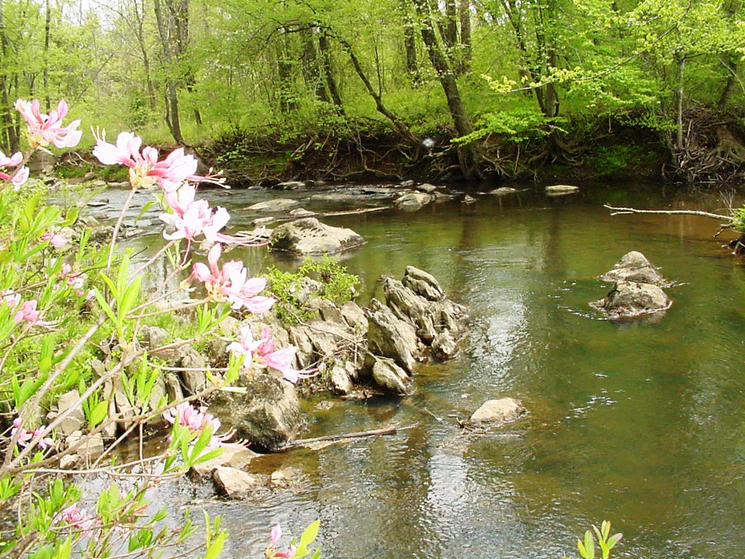
New Hope Creek rises in Orange County, flows through southwestern Durham County, and then feeds into Jordan Lake, which was created by the US Army Corps of Engineers in the 1970s and 1980s to control flooding downstream and now provides drinking water to many Triangle residents. Water from Jordan Lake feeds into the Cape Fear River, which flows southeast through the Coastal Plain before meeting the Atlantic Ocean near Wilmington.
Between the headwaters of New Hope Creek in Orange County and the Orange/Durham county line, the topography around the Creek and its tributaries consists largely of rolling hills typical of the Piedmont region, underlain by hard igneous and low-grade metamorphic rock that in some areas is over half a billion years old. The Creek flows quickly, winding among large rocks and bluffs. Near Hollow Rock Nature Park, however, the Creek changes as it enters the flatter, lower-lying Triassic Basin. The Creek slows down, and the hills and bluffs are replaced by some of the richest bottomland forests in central North Carolina. The County's New Hope Creek Bottomlands Trail, at New Hope Creek Preserve, allows visitors to explore part of this unique ecosystem.
By the 1980s, much of the land in the southern part of the New Hope Creek Watershed was protected and managed for conservation as part of the Federally-owned Jordan Lake Game Lands. Similarly, the rural setting of the Creek's headwaters faced comparatively little development pressure and included large areas of managed land, such as Duke Forest. There was great concern, however, about the area in between - the New Hope Corridor, which includes New Hope Creek and its tributaries in parts of Durham and Orange Counties. Citizens, nonprofit organizations, and government agencies worked together to create the 1991 New Hope Creek Corridor Open Space Plan, adopted jointly by Durham County, Orange County, the City of Durham, and the Town of Chapel Hill. Since then, Durham County has protected over 300 acres between the County line and the Jordan Lake Game Lands, with hundreds more protected throughout the Watershed by other local governments and organizations.
Upper Neuse: The Little River
The north and south forks of the Little River converge in northwestern Durham County near South Lowell Road. The Little River then flows east until it feeds into the Little River Reservoir, one of the two primary sources of drinking water for the City of Durham (the other being Lake Michie, in the Flat River Watershed). Southeast of the Reservoir, the Little River flows through the Federally-owned Butner/Falls of Neuse Game Land until it converges with the Eno River. The Eno River, in turn, feeds into Falls Lake just downstream of the convergence. Like Jordan Lake, Falls Lake was created by the US Army Corps of Engineers in the 1970s and 1980s to mitigate flooding; today, it serves as a key drinking water source for the City of Raleigh. The Neuse River - which was dammed to create the Lake - flows east from Falls Lake and empties into Pamlico Sound. Much of the land along the Little River in Durham County consists of rolling hills and, in some areas, dramatic north-facing bluffs whose microhabitats bear resemblance to areas in the North Carolina foothills. The river itself is important both as a source of drinking water for City residents and as habitat for a variety of important and imperiled aquatic species, including Federal- and State-listed invertebrates.
Durham County began protecting land along the Little River in the mid-1990s. In 2001, the County adopted the Little River Corridor Open Space Plan, the County's second Open Space Plan. Like the 1991 New Hope Corridor Plan, the Little River Plan identified key areas for permanent protection throughout the Little River watershed in Durham County. The County now owns over 600 acres of conservation land along the Little River and has protected hundreds more acres in the watershed through voluntary, permanent conservation easements on privately-owned working lands.
Upper Neuse: The Flat River
The Flat River, which flows south from Person County into northern Durham County, and its tributaries feed into Lake Michie, one of the two primary sources of drinking water for City of Durham residents. From Lake Michie, the Flat River flows southward, roughly parallel to the Durham/Granville county line, before meeting the northern end of Falls Lake. Created by the US Army Corps of Engineers in the 1970s and 1980s by damming the Neuse River, Falls Lake helps mitigate flooding in the Neuse River Basin and is a key drinking water source for the City of Raleigh. From Falls Lake, the Neuse River flows east through the Coastal Plain to Pamlico Sound.
Much like the topography along the Little River, much of the land in the Flat River watershed is hilly and rocky, with lower-lying bottomland forests located closer to Falls Lake. The setting is predominantly rural, and it is in this area where some of the County's most extraordinary wildlife - bears, bobcats, and timber rattlesnakes, to name a few - are most likely to be found. The River and its tributaries provide excellent habitat for an array of aquatic species, too, including unique and rare invertebrates. The largest tracts of managed, publicly-owned conservation land in this part of the County include Camp Butner, Hill Forest, and the City's land around Lake Michie.
The County has permanently protected over 1,000 acres in the Flat River watershed, nearly all of it through partnerships with landowners who have chosen to place conservation easements on their working lands. Protected, well-managed working lands like farms and forests help conserve soil, safeguard imporant habitats, and permanently limit impervious surface and development - all important for protecting our County's water resources.
Upper Neuse: Lick Creek, Little Lick Creek, and Panther Creek
Eastern Durham County has seen extensive development and land use change in recent years. This development provides great benefits to County residents, including housing, economic growth, and jobs; at the same time, it can place pressure on the region's water resources. Since 2010, Durham County has protected nearly 400 acres in eastern Durham County near Lick Creek, Little Lick Creek, and Panther Creek to protect water quality. County Open Space staff have also been working with other County and City staff to provide technical input for the forthcoming Southeast Durham Watershed Improvement Plan, and have worked with researchers to study ecosystems in this part of the County.